Weekly history columns in the Sausalito Marin Scope are provided from the archives of the Sausalito Historical Society. Stories from the past are shared with the general readership of the newspaper.

Wednesday
Jun042014

The Off Ramp to Nowhere

By Larry Clinton
It sounds like something out of Kafka, but if you’ve ever mistakenly taken the Rodeo Ave. exit off Southbound 101, you know it’s certainly no fiction.
The freeway exit was constructed in the ‘60s to allow access to the infamous planned development in the Headlands above Sausalito called Marincello. The development was finally abandoned after long legal battles which are described in the recent documentary “Rebels With a Cause.”
One of the attorneys who fought that David-vs.-Goliath battle is Doug Ferguson, who described the legal struggles at the recent annual membership meeting of the Historical Society.
Marincello was planned to house up to 30,000 people in apartments, homes and townhouse and would also include a mall and hotel at the high point of the headlands. Working with Gulf Oil, a Pennsylvania developer named Thomas Frouge purchased 2,000 acres of land and made immediate plans for the new community.
Despite protests from local preservationists, In November 1965 the County of Marin officially gave Marincello a green light. Large gates were immediately built in Tennessee Valley marking the entrance for new city. A wide boulevard was carved up the mountain to be one of the main streets in and out of the community.
After much legal maneuvering, Doug Ferguson, with colleagues Bob Praetzel and Marty Rose,
filed a lawsuit claiming that Marincello had been improperly zoned back in 1964 and allowed the public only six days to review the zoning instead the legal ten days. The lawsuit led to discovery of other inaccuracies in the Zoning Outlines that Marin had approved in 1965.
By 1966, thanks in part to the legal delays, the budget for Marincello was ballooning from its original $250 million price tag, and 1967 construction was halted.
In 1972, the land was sold to the Nature Conservancy and transferred to the newly formed Golden Gate National Recreation Area.
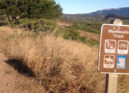
Today the main boulevard is a popular hiking, biking, and horse path, appropriately called the "Marincello Trail." It’s accessible from the Rodeo Ave. exit, via the Bobcat trail. If you’d like to explore the trail and its spectacular views, you can park near the end of the off ramp, but be aware that it’s a long, steady uphill trek and then a series of up-and-downhill connections to reach the Marincello Trail.


Marker for Marincello Trail.
Photo by Larry Clinton

Thursday
May222014

Working Waterfront: Keeping It Alive

By Steefenie Wicks
Sausalito’s traditional working waterfront is small but very much alive.   There are boat builders, shipwrights and ship captains working from small locations, making a living in their crafts.  Most of the training that keeps this working waterfront heritage alive comes from past students of the Arques Traditional Boat Building School, under the direction of Bob Darr.
Jeff Reid, Jody Boyle and Anton Hottner are all graduates of the school and all three have small shop spaces at Gate 3, one of the last spots on the Sausalito waterfront where such a thing is possible. None have been able to secure leases to their spaces, and this is bit unnerving because it offers no real security for them.
Jeff Reid was born and raised in Skaneateles, New York, an area full of small lakes. Even though his parents did not have a boat his friends did, so at the age of 8 he was on the water.   The same can be said for both Anton Hottner and Jody Boyle.  Anton was born in Germany, Jody just outside of Boston. That love of the water and sailing is what eventually brought the three of them to the Arques School.
Jeff would be the first to tell you that while he has been working here as a shipwright for the past 15 years, he has never had a business card or advertised his skills; all his work comes by word of mouth.   His mainstay is woodworking on repairs and restorations which he feels are the bread and butter of Arques School graduates.
He believes that the maritime shops, service people, and waterfront workers who now inhabit shop spaces at Gate 3 are a close-knit group that survives because they both work and play together. This includes helping Heather Richard at Cass Gidley Marina by volunteering to work on the small boats that have been donated to the organization.
Captain Heather Richard, who stands 5ft. 2 inches, commands tall sailing ships in the Bay area.  She also hails from the Boston area, and started sailing when she was around 6 years old on a wooden Sunfish.  She coached sailing out of St. Francis Yacht Club in 2000, working privately in the sailing community of the Bay area.
For the past five years, Heather has been working on a project known to locals as Cass’s Marina.  She explains: “This is a public city-owned property that went out of business. A group of us got together and formed a non-profit organization to have a waterfront sailing program at this location. Work has been slow but donations are just starting to come in recently. Oracle donated a bunch of docks after the America’s cup races. The engineering for the ramp has been done, the pilings have been driven, and the Lions Club has pledged $10,000 and manpower to help re-build the office.”  Heather and her committee are now putting together a fleet of small boats.
Heather has a near coastal 100-ton master’s license, which allows her to run charter boats the size of Gaslight and a little bigger.   She is working on board a USA 76, which is an old America Cup’s boat now under charter in San Francisco.  It’s a very long process to learn how to run this vessel that is 84 feet long, the largest boat she has worked on. Because of her size she has had to be better than most of her male counterparts.  But she feels that once she is on board and the crew starts to see what she is capable of; they soon change their minds.   
Jody Boyle, who is currently working on a 40 ft. yawl, has been at his shop at Gate 3 for the past 10 years, and had no idea that he would be in one space so long.  But he has plenty of work, which makes his month-to-month arrangement worth it.    His skills bring him work from outside Sausalito so he travels to different locations doing boat repairs and vessel restorations. He mentions how the most important things he learned from Bob Darr and the Arques School was lofting, hand tool work and that attention to detail.  “The school was awesome,” he says.
For the past 3 years Anton Hottner has worked on the 136-foot long luxury motor yacht, the Acania.  He was recently commissioned to design and build a 17ft lapstrake rowing boat.  His client Doug Gilmore, who believes in supporting the working waterfront, has purchased 3 small boats that both Anton and Jody have worked on.
Anton feels that the importance of the waterfront is that “It’s alive.”  He says: “If you change the zoning, condos can take over shop space and then it becomes a ‘dead’ experience. “
The boat-building heritage of the waterfront is alive because it is passed on.  Recently, a family came to pass on their father’s boat building tools because they felt they should be used. The family decided to seek out boat workers in Sausalito, and found Jody and Anton.  To their surprise they ended up with a set of beautiful specialized wooden tools, most of them hand made.  Anton says, “When you pick up a tool and feel the handle you can almost feel the man who used the tools, the romance of what he was building with that tool.”
Heather feels that Sausalito is one of the few places in the country where new wooden boats are still being built. “There are a lot of talented young boat builders working here and we are now starting to see that maybe fiberglass was not that good because it did not last as long as people thought,” she observes, adding,  “Maybe we should be looking for new materials that would work, but the traditional wooden boat is still preferred.”
Many vessels return each year to have repairs done only in Sausalito by the shipwrights from the Arques School -- vessels like the famous 52-foot yawl Dorade.   Designed by Olin Stephens in 1929 for $28,000, the Dorade would change the way people thought about sailing.  Recently she was docked at Schoonmaker Marina where Jeff and Jody were commissioned to do repairs on her.
They work together, they play together … Heather, Jeff, Anton and Jody all have one thing in common: a love of what they are doing which gives them the right to pass that on to Sausalito’s next generation of waterfront workers.  


Jody Boyle, Anton Hottner, Heather Richard and Jeff Reid (left to right)
Photo by Steefenie Wicks

Wednesday
May212014

Strawberry Point: ‘The Capital of the World?’

MarinScope

March 26 - April 1, 2014

By Brad Hathaway & David Siegel, Sausalito Historical Society 

If architect William W. Wurster had had his way, Frank Lloyd Wright’s Marin County Civic Center might not be Marin’s most famous post-World War II building. It was Wurster’s idea that the slender peninsula jutting into Richardson’s Bay called Strawberry Point would have sported not homes and a Baptist Seminary, but instead, a “World Peace Center” serving as the permanent headquarters of the United Nations.


Charlene Mires, an Associate Professor of History at New Jersey’s Rutgers University, has published a book detailing the efforts of many communities around the country, and for that matter, around the world, to become “The Capital of the World” by hosting the UN, an effort which finally ended with New York City receiving the honor. She unearthed some 248 proposals or suggestions which earned at least a passing nod for the honor back in 1945.


Among the proposals Mires unearthed was one prepared by Wurster and two colleagues, Ernest Born and Theodore C. Bernardi. They prepared a plan which would have accommodated a domed auditorium capable of seating 10,000 delegates, staff, press and the public as well as office buildings for the organization’s permanent bureaucracy and a library/archive/museum to house and display the documents of this new world body.


While most proposals for a home for the United Nations would be expected to include facilities like those, the plans for Strawberry Point included such unique features as a small craft harbor to allow commuting from San Francisco by boat and a “Seaplane Landing Base.”


A ceremonial “Court of Flags” and the plaza surrounding the main auditorium would have faced toward the northeast with the Tiburon Peninsula as its vista, but sloping down the western edge of the point facing Sausalito would have been the library and both an indoor and an outdoor museum. It would have placed a broad plaza approximately where the homes on Starboard Court are today.


Architect Born waxed eloquent in his description of the site and the plan, saying “Caught in the meeting of land, sky and sea there is a sense of unity understandable by people of anywhere in the world. Unhampered by political prejudice or selfish bias, Strawberry Point, Marin County, has been selected by the architects as the area in the Bay Region possessing in highest degree features of a building site for a center of world importance. The site of unsurpassed beauty, indefinitely expandable generally northward and accessible to the bay cities is at once detached from urban cramp while still part of the urban scene.”


Northern California and the Bay Area had reason to anticipate the possibility of the United Nations establishing its headquarters here. The Charter of the United Nations was formally established in a two-month conference where delegates from 44 nations met in San Francisco’s Opera House between April and June of 1945 as World War II was coming to an end and the form of the post-war world was beginning to take shape. It was, and may still remain, the largest single gathering of an international conference, with 850 delegates, nearly 2,000 advisers and staffers and over 2,500 reporters.


Mires’ book, Capital of the World: The Race to Host the United Nations reveals that just what the UN would require once it got underway was unclear at the time. Would a new city be founded as a “World Capital” with embassies for each of the member countries, residences for staff and all the accouterments of a capital city, or would a “Headquarters” within an existing locale be sufficient? Wurster, Bernardi and Born assumed a working headquarters would suffice, but that it should be of a design that spoke both to the dignity of the organization’s goals and of the aspirations of a world tired of war.


The Strawberry Point proposal wasn’t the only Marin County entry in the very informal competition for a “World Peace Center,” “Capital of the World” or “Permanent Headquarters for the United Nations.” California Democratic State Senator Herbert W. Slater of Santa Rosa introduced a joint resolution in Sacramento which, if it had passed, would urge the placement of the facility - whatever it might turn out to be - “in a redwood grove in the west’s world famous Redwood Empire.” While that might have been some redwood-rich area on the North Coast, it might just as well have proven to be the grove in Muir Woods where the United Nations held its memorial tribute to Franklin Delano Roosevelt on May 19, 1945.


Mires’ book details the way that New York City earned its place as the UN Headquarters with the last minute agreement of John D. Rockerfeller, Jr. to fund the purchase of the site on the East River between 42nd and 48th Street for the UN at a price of $8.5 million. Adjusted for inflation, that would amount to over $110 million today. Strawberry Point couldn’t compete with that.

Wednesday
May212014

The Rainbow Tunnel Shines On

MarinScope

TUESDAY, NOVEMBER 13, 2013

by Brad Hathaway

In 1970, what is now CalTrans took a utilitarian piece of infrastructure and turned it into a landmark, comining the uniquely Marin-ish mixture of whimsey and wonder with the utility of a major highway structure.

As Alan S. Hart, the director of the San Francisco District of California’s Division of Highways, prepared to retire, he and his public information officer, Robert Halligan, came up with the idea of painting the southern portals of the Waldo Tunnels of U. S. Route 101 with a rainbow of colors. Hart didn’t bother to clear the idea with his superiors in Sacramento and it is reported that they were not pleased – but the public reaction was so positive they let the colors remain.

Originally, there had been just one tunnel. It was constructed in 1937 as part of the Golden Gate Bridge project to connect San Francisco with Marin County and the rest of Northern California. The tunnel was 1,000 feet long and the elevation at the entrance was 517 feet above sea level. It cost $630,346 in depression-era dollars.

By the 1950s the single, four lane tunnel had become something of a bottleneck sitting as it did just north of the six lane Golden Gate Bridge on the Redwood Highway. A second tunnel was drilled in 1954 so that the highway could handle four lanes in each direction. The cost of that second tunnel came in at $1,750,000.

After the portals to the tunnels took on the spectrum of the rainbow, legends that seem to die hard sprang up about hippies sneaking out in the middle of the night to surreptitiously apply the paint. After all, the age of flower-power and psychedelic color schemes was at its peak. The fact that no crew could have done the work in a single night didn’t seem to keep that legend from spreading.

As the fame of the tunnels grew, the rainbows became part of the area’s self-image, and the drive under the rainbow became a delight both for commuters approaching home and for tourists following the Redwood Highway to the north.

But time took its tole on the vibrancy of the rainbow spectrum. The paint faded badly. In the 1980s CalTrans repainted the portals, but by 2009 they needed another coat.

Enter Belinda Hallmark, a color consultant from Novato.

Hallmark read that CalTrans was planning on renewing the paint job and thought she might be able to be of assistance. After all, as a color consultant she knew a great deal about how different colors would go together and how different paints would behave.

Of course, a rainbow would include red. But which red? Green, but what shade of green? Yellow, but would the yellow be lemony or golden?

Hallmark feared that simply applying bands of primary colors might end up with the tunnels looking “more like a roll of Life Savers than like rainbows,” so she contacted CalTrans to offer her services – gratis.

With the cooperation of the paint team of CaTrans’ Maintenance Division 4, plans were laid for the job. Hallmark painted test swatches to judge not only how different colors would work together, but how they would behave in the wide range of lighting conditions the weather offers for those south-facing arches: direct sun through morning mists, sharp twilight shadows, rolling fog banks and wind-driven rains. As often as three times a day she would drive Route 101 to check the samples.

Not only did Hallmark help determine the colors to be used, she chose the paint and even got it donated for the project. Benjamin Moore’s Aura was the paint of choice and the company donated half of the paint required for the job. Their generosity was matched by Marin Color Services, Inc., the Benjamin Moore outlet in San Rafael and Novato.

There was thought about painting the north side portals as well, but they were in sight of private residences and not all the homeowners thought seeing painted rainbows was the view they wanted.

Hallmark convinced CalTrans officials that the north face of the tunnel and not just the arched portals shoud be painted. She chose a green for the flat surface and a grey tone for the pop-out concrete blocks. This was to provide a more distinct background for the rainbows.

In all, it took 30 gallons of paint for the rainbows themselves, 40 gallons for the wall surfaces as well as a total of 40 gallons of primer, and an additional 20 gallons of clear sealer for the rainbows.

CalTrans’ Jeff Buttte and his Richmond/Sn Rafael Bridge Painting Crew did the work in September and October of 2009 at a cost of about $142,000 for the 3,000 hour job. That included a dozen painters and a half-dozen person lane closure/traffic control crew. In all, almost 10,000 square feet of surface outside and within the tunnels were coated.

Hallmark still drives up to look at how the rainbows have fared. “There’s no sign of fading” to date, she says.

A sentiment echoed by my granddaughters who love to go through the Rainbow Tunnel!


Wednesday
May212014

Angel Island The gem off our coast

MarinScope

TUESDAY, JUNE 5, 2013

by Brad Hathaway

For most residents of Sausalito, the view from the water side of your home isn’t of the Golden Gate Bridge, San Francisco, Belvedere Peninsula or even Strawberry Point. It is Angel Island which forms our front porch.

A book detailing The Islands of San Francisco Bay provides a wealth of information on the history of Angel Island from its geological formation to its role as a safe haven, a military installation, an immigration station and a park.

James A. Martin, who conceived of the book and wrote a good deal of it himself, visited the Sausalito Historical Society at its May meeting and explained that the project was more than just a textual one. He photographed the scenes on the bay’s major and minor island to make the book a thing of beauty as well as of interesting information.

Appropriately enough, in an introduction by Paul McHugh, the book begins with the history of the bay region itself, going back some fifteen thousand years to the peak of the last ice age when what are islands today were just hills on the plain that became the bay. Then, the ocean lay over 30 miles to the west of the Golden Gate and the rivers draining California flowed out to a huge cliff miles beyond the Faralons.

Today, Angel is one of seven major islands in the greater San Francisco Bay: in alphabetical order they are Alameda, Alcatraz, Angel, Bair, Brooks, Mare and Yerba Buena/Treasure. Each receives full attention in a separate chapter in Martin’s book, along with additional chapters on collections of less major outcroppings such as Red Rock and the Brothers and Sisters.

In Angel Island’s chapter, written by Jonah Owen Lamb, we learn that prior to the arrival of Europeans in the bay area, Angel Island had hosted occasional seasonal visits by Miwok people, but apparently it never had a permanent settlement. Then, in 1775, the San Carlos, a Spanish vessel under the command of Juan Manual de Ayala, became the first European vessel to sail into the bay.

Ayala named the island Isla de los Angeles and used a cove on the north side of the island as a base for extensive charting of the bay. That cove was named for the captain. Nearly forty years later the British Cormorant-class sloop Racoon beached at the cove for repairs. Using a more modern spelling, the strait between the island and what is now Tiburon, which is more than 200 feet deep, has become the Raccoon Straits.

In the 1830s, Antonio Maria Osio owned the island as part of a Mexican rancho and grazed a herd of Long Horn Cattle. He built houses for his cowboys and had a thriving business until Mexico lost California and he lost his rancho.

Lamb sketches the on-again, off-again history of military uses of the island between 1863 and the end of World War II. “Several gun batteries facing the Pacific were built by the military, and installations and bases around the island housed, shipped and trained soldiers for years” he says, adding that “to this day, the military presence still permeates the place.”

But it is, of course, the history of the use of Angel Island as a US Immigration Station that dominates the reputation of the island. It earns a separate sub-chapter in the book titled “Picture Brides and Paper Sons” in which Joe Mudnich sketches, in human terms, the impact of the Chinese Exclusion Act of 1882 and the 1907 “Gentlemen’s Agreement” with Japan which meant that the role of the facility was, as he says, “not so much to welcome most newcomers as to guard against them.” Mudnich points out that this history means that the station “was not exactly the ‘Ellis Island of the West’ as it is often called today.”

He says that between 1910 and 1940 as many as a million people, “mostly from China and Japan” were processed through the more than four dozen buildings on Angel Island’s “China Cove” before either entering or leaving the United States. The cove’s name, by the way, was a reference to Chinese shrimpers who camped there long before there was an Immigration Station there.

“Angel Island” was also the name of the 144-foot steamer that shuttled passengers back and forth between the island, San Francisco and the ships in the bay. Today, it is the name of the California state park which holds the entire island with the exception of an unused Coast Guard facility. Martin’s book contains as many as thirty five color photographs to illustrate its description of the island as it exists today, and the sketch of its history, which makes a visit to Sausalito’s “front porch” a day trip to remember.


Page 1 ... 8 9 10 11 12 ... 26 Next 5 Entries »